Showing posts with label Metropolitan Bible Church. Show all posts

Wednesday, November 6, 2013

Metropolitan Centretown

Looking south at Bank and Gladstone on a rainy dusk in early September. (Sigh, at a quarter to 8pm!)


I'm not particularly fond of the development here, nor the way the former Metropolitan Tabernacle's façade has be entirely de-animated as it has succumbed to death-by-Shoppers. But because the building is so close to the street, the developer was forced to bury the power lines. That on its own is a plus, but in addition it has meant full-fledged streetlights instead of the light heads tacked on to wooden hydro poles.

I suppose that arguably there is a pedestrian component to that to warrant adding "Peds on Weds" to the title of this post, but really I just wanted to post this picture because I like the colours.

[Tune in on Wednesdays at noon for a new pedestrian-themed blog post. View the Pedestrians label for previous Peds on Weds posts]
[Look for more one-photo posts under the label Singles]

Friday, June 1, 2012

384 Frank Street

Frank Street is well known for its grand houses, many of which span the entire block to Gladstone Avenue. It's also very pretty in the Golden Triangle. West of O'Connor, it's mostly apartment buildings of various sizes, vintages, and condition. But bucking the trend just behind the old Higgerty's Shoes building is this little house with a flagstone exterior.

Its star-shaped weathervane is a little hard to see in front of the new Central condos (formerly the Metropolitan Bible Church). It's also right across from the parking lot next to Centretown's only (thankfully!) big box store, Staples. Between the two, 384 Frank Street is much more pleasant to look at as you walk by!

[Look for more one-photo posts under the label Singles]

Friday, December 16, 2011

Central corridor

The Central condominiums, at the site of the now-demolished Metropolitan Bible Church, are nearly done the first phase. It looks like people have started to move in, and if they haven't, it sure won't be long. (Modern Ottawa has had a number of posts on the construction of Central)

Recently, work started on phase two, the first public inklings of which were two years ago, and the plans for which have been approved virtually unchanged from the early pre-application renderings.

They've had to remove the Bank and McLeod bike cutout, and have installed some scaffolding to protect the pedestrian passage, which gives the impression that it goes on and disappears into nothing.

[Look for more one-photo posts under the label Singles]

Wednesday, June 15, 2011

340 McLeod demolition

We've known for a long time that the former "Medical Building" at 340 McLeod (near Bank) would likely be demolished for Phase 3 of the Central condos at Bank and McLeod (Phase 1 is currently under construction, with the Metropolitan Bible Church façade). This was recently confirmed at City Hall, where the rezoning application was approved with adjustments made based on CCCA feedback.

Most people see the building from Bank Street (like at Tommy & Lefebvre), but here's another view looking across the block from Argyle, here in late May...

And again just this past weekend, where they have begun demolition. While 340 McLeod goes down for Central Phase 3, Central Phase 1 is well on its way up behind it.

I haven't been by there since the weekend so I don't know how far along the progress is on demolition. If you know, please leave a comment.

Friday, December 17, 2010

Signed, Gladstone and Bank

My keen observational skills, combined with a two-year archive of photos of a an intersection, helped me piece together a little puzzle at Bank and Gladstone that I came upon while preparing the post on 433 Bank Street.

Here's a shot of the intersection in question in December 2008. At the time, my intent was to photograph the Metropolitan Bible Church, but we also can see three street signs for Gladstone Avenue, at the NW (closest), SW (partly obscured) and SE (furthest) corners. It may not be apparent in this photo, but all three signs have a typo: they read "av. Gladstone Av." instead of "Ave." for the English name.

In the photo above, the Bank and Gladstone signs at the southeast corner were on the same post. The sign at the SW corner--the corner with the Esso station--is on the street side of the post. By June 2009, seen below, it had been flipped around to the building side of the post. The bundle of wires (which were there to accommodate the many changes to the traffic signals during last year's reconstruction of Bank Street) suggests a motivation. The Bank and Gladstone signs are at the same height. Gas is listed at 94.2 cents per litre, but the station is actually closed for repairs.

There are two extra holes on the far side of the sign, but the sign is nevertheless backwards (the arrow on the street numbers is pointing the wrong way). My guess is that the two new holes were drilled so that the sign could be flipped to use the new holes, but that the installers didn't bother to remove it from the mount to flip the sign.

In mid-October 2009, the Gladstone sign was flipped back to the street side, and the jumble of wires are gone. The Gladstone and Bank signs are at different levels, and gas is at 88.9. We know it's the same sign because it has the two holes.

Looking up at the intersection from McLeod street in mid-November 2010, the sign on the northwest corner was moved to a different pole and is facing away from Bank street. It's very definitely not visible from the southbound lanes on Bank.

That same month, a new "av. Gladstone Ave." (sic) sign appeared at the southeast corner--clearly a new sign. It's attached to the metal pole on this corner. Here's a photo of it on February 20, 2010, with the Metropolitan Bible Church facade in the middle of the street. Of course, at the time I wasn't taking a picture of the sign!

The Bank street sign on the east side had been relocated to the North corner. The "Gladstone Av." sign at the northwest corner had been returned to a position where it is visible from the southbound lanes on Bank.

In March 2010, there was some work going on at the southeast corner. The metal pole (being held up by the crane) was either being removed, installed, or relocated.

Meanwhile, here in late May as above in March, the Gladstone sign with the spare holes on the southwest side appears to have disappeared. Gas is still hovering around 94 cents per litre. (Okay, this picture is somewhat redundant, but I really like this shot of the Central's tower crane)

The sign at the southeast corner was moved to the wooden pole, possibly during the exercise in March. The photo below is in August 2010.

The mystery, from your perspective, might be where did these signs end up. For me, the mystery was where did it come from--I already knew where it ended up: in my window!

Appropriately facing Gladstone Avenue. Whatever the original reason for the spare set of holes, they came in very handy in suspending the sign with fishing line.

The other one is presumably still available from where I got this one--on the City of Ottawa's Decommissioned Street Name Signs listing. You can buy used signs for ten dollars, tax in, and pick them up at the Traffic Operations Division building on Loretta. But they're big. The photo above might be deceiving, as the window opening is around 60" wide, making the sign about four feet long (though this is a larger size of sign).

I posted a three-part tour of those facilities in March 2009. In the second part I showed their decommissioned street signs.

The sign itself is neat to own--especially living on Gladstone--and it's that much more interesting that I was able to track a bit of its history (even though, as one of the blue signs, it's no older than the City's amalgamation in 2001).

This story also demonstrates the usefulness of taking lots of photos, because you never know what little detail in the background might be useful.

Friday, September 24, 2010

Gladstone near Bank

In mid-August, I snapped this photo of the building that houses the Rama Lotus Yoga Centre, among other businesses. Next to it is Pierre Amelotte International, a more yellow former house. Behind that is the tower crane for the Central Phase 1 (site of the former Metropolitan Bible Church).

Behind the tower is a sky that gives off just the right amount of light to make for a nice photo.

By sheer coincidence, iKen posted a photo of this same building on his blog after I'd prepared this post but before it was scheduled to go up. I've had a lot of that lately!

[Look for more one-photo posts under the label Singles]

Monday, March 1, 2010

Defacading a heritage church

There's other coverage at URBSite (link at end of post) on the removal of the Metropolitan Bible Church wall, so I thought I'd so something a little different.

I'm restricting the photos in today's post to shots from more or less the same angle, showing progress of work on the façade.

Here's how it looked on November 3, 2009, more or less in its original state:
By November 23, the canopy had been removed.


On November 25, a scaffold was under construction:

The next day, two workers installing a mesh watch me take a photograph. With my new camera, I'm able to fit the whole facade into frame.

By December 8, 2009, the parapet at the top of the wall had been dismatled, for reassembly once the new building was complete. The signage attached to the building was also being removed.

Three days later, we can see the result more clearly now that the scaffolding and mesh have been removed. In addition to the parapet, the second and third storey windows have been removed. The ground floor windows and doors remain intact.

By the 22nd of December, the wooden doors had been removed and the openings boarded up.

Another month later, on January 24, 2010, there was an enclosed plywood work area at the base of the wall.

By February 17th, a steel truss structure had been assembled on the inside and outside of the walls, sandwiching the wall with foam inserts.

Here it is again on Sunday, February 20th, 2010, only something's different...

As you can see from the buildings at the left and right edges, this is the view of the front of the building during the gigantic façade removal procedure. The streets were closed on all four blocks heading away from the intersection of Bank and McLeod, and most of those streets were occupied by flatbed trucks, cranes, police cruisers and other construction-related vehicles.

Looking down McLeod Street, here's the rear view of the front of the building. (How often can you say you saw that?)

And here's the façade again the next day, only it's one and a half storeys underground, stowed away while the new foundation is built in its permanent home.

Here's the front shot of the building once again, literally a cross-section of the building:

Regrettably, I neglected to take any more photos from across the street once the façade came off. But I have plenty more interesting photos from different angles that I will post in the coming days and weeks, and of course I'll be taking more photos as demolition and construction continue, right up through when the façade is returned to its original location.

While you're waiting, don't forget to check out other posts with the Metropolitan Bible Church label.

Edit: See also the URBSite post on the removal of the Bible Church wall

Saturday, December 12, 2009

Central Phase II - what do you think?

Buried at the end of the previous post, I mentioned that Councillor Holmes orgnized a public meeting at Centretown United Church for the builders of the Central condominiums to share their plans to build a second building at Bank and McLeod.

Here's a panoramic view of the area on Bank Street, looking East (click to enlarge). On the left is the Metropolitan Bible Church, under disassembly/demolition, then McLeod Street, then the Medical Building at 340 McLeod with large parking lot at Bank, then the CLV building (whose tenants include Vistek, where I got this new camera), the tower of Centretown United, and finally Bank Street. This is across the street from Tommy & Lefebvre's flagship store, under reconstruction after the fire this past March.

Below is a rendering of roughly how this same view might look. On the left is the Central Phase I (permits already approved, construction underway) with the Metropolitan Bible Church's façade retained. In the middle, across McLeod Street, would be Central Phase II, separated from the CLV building by the CLV building's parking lot.

Thanks to Natalie at FoTenn for getting me a electronic copies of the panels from Tuesday's presentation. The graphics were prepared by Core Architects, the Toronto-based firm whose Ottawa developments include the East Market building, the Mondrian, and of course the Central Phase I. Note that the renderings are all preliminary, and no applications have been submitted to the City at this point.

Here's the site as it sits today at Bank and McLeod. That brown building with the tall windows is the Medical building, and it has sat vacant for eight years. Along the Bank Street frontage is a large parking lot, all part of the same parcel as the Medical building. David Wex of the development company said they purchased the site a month or so ago, with some final paperwork left. Note the bike cutout on McLeod at Bank, so cyclists can go straight or turn left from McLeod, but motorists must turn right. This will likely be retained.

A corollary of the building having been vacant for eight years is that these signs at Bank Street are unnecessary clutter. (This photo was taken last December, before the reconstruction)

Here's a view of the site and zoning from the City of Ottawa's eMap application. You can see that the medical building and the parking lot are all the same property, and the way the parking lots fit together like a jigsaw.

The eMaps property report shows that the zoning is TM H(19) - Traditional Mainstreet, maximum 6 floors, maximum height 19m, with a Heritage Overlay. The developers will be asking for variances for an additional two storeys, plus a reduction in setback requirements along Bank.

As for the proposed development, they want to build on the popularity of the Central Phase I development (Matt Richling has a good writeup of it on his Ottawa Real Estate blog), which has already sold 200 units of 240. Instead of the U-shaped building of Phase I, Phase II will be an L-shaped building of similar style hugging McLeod and Bank streets. The medical building will be leased or sold (and if they can't find any takers, they'll consider a Central Phase III). Here's a comparison of Phases I and II, again from the Core Architects document:

340 McLeod Street and 453 Bank Street - Statistics Summary

Date: 08 December 2009
Projects: 09-205 and 07-160
 Central Phase 1Central Phase 2
Total Residential Units237131
Total Floors98
Building Height31.8m (Top of Level 9)28.7m (Top of Level 8)
Parking138 spaces provided for residential parking
40 spaces provided for retail parking
91 spaces of which 67 are residential and 24 visitor
Commercial Area (m2)1,856688.4
And here's an aerial rendering from Core Architects of what the two buildings are proposed to look like on the site. We're looking West, with Phase I on the right, and Phase II on the left, with the Medical building in front of it.

Here's another rendering of the street view looking West along McLeod toward Bank. The Medical building holds up better to the mass of Phase II than the houses on McLeod do to Phase I.

For comparison, here's a similar angle in Google Street View (the embedded street view was causing errors, so you'll have to click to explore):


Now, it's hard to make it out in this flat elevation, but we're looking at the building from the South, with Bank Street on the left and 340 McLeod on the right. The bottom of the "L" is at the left in red brick, and the rest of the building is further back. In the spirit of the LEED design principles, the developers are planning to build a Green Wall along the single-storey wall abutting the CLV parking lot. Above this first storey will be a landscaped courtyard for the residents.

On the ground floor of the building, they've got some interesting proposals going on, as shown in the rendering below. The greyish area represents ground-floor retail. They're suggesting the possibility of an urban-format grocery store in that space. The red bit is the lobby, and the yellow squares are "loft-houses," essentially two-storey townhouses at the base of the condo tower with entrances on McLeod. At the back of the site (inside the building) is the entrance to the two-level parking garage, which will have room for residents and visitors (retail parking for both phases will be provided in the Phase I building, which has only sold 70-80 parking spots of the 138 allocated to residences, leaving many available to add to the 40 spots already reserved for public parking). Lastly, a loading dock at the south-east corner of the building interior will share the same set of doors as the garage.

The timeline for the applications process was described on this panel. We're currently in the 'pre-consultations' phase, and the developers expect to submit their applications around the end of January 2010. This is when the formal public process will begin. At the meeting, Councillor Holmes suggested that residents should wait for the applications to be submitted before sending comments to the City, but I am of the opinion that it's never too early.

There was a wide variety of opinions expressed by those in attendance at the meeting on Tuesday. Some neighbours to the site were worried about the building being two stories higher than what the zoning allowed. A couple of people who recently bought houses in the area enthusiastically welcomed the increase to their property's values, "so keep going," they said. Other concerns included the loss of parking and whether the green wall would get enough light to survive, or if it instead would become an alley attracting graffiti.

The proponents said that the pair of developments would create an "European feel" with a consistent building form across multiple streets.

What do you think?

The CCCA's Planning and Development Review Committee will be discussing this proposal, likely at their January committee meeting, and I'd like to hear feedback from residents to bring to the committee to inform the Community Association's position. Leave your comments in the "comments" section below, or drop me an e-mail at Centretown.Ottawa -at- gmail -dot- com

Lastly, here's the latest view of the Metropolitan Bible Church. They've finished dismantling the top of the Façade and have removed the scaffolding.

Thursday, December 3, 2009

Metropolitan Bible Church demolition PLUS TWO SURPRISES

The Metropolitan Bible Church (future "Central" condos) demolition/construction site is just full of surprises. Last time, it was the affectionately titled photo Bucket Feet. This time there's even more, which I'll get to at the end of this post...

For the uninitiated, the Metropolitan Bible Church is a former church on Bank Street between Gladstone and McLeod. It was built as the Metropolitan Tabernacle from 1934-1936, and is in the Centretown Heritage Conservation District. The congregation moved to new digs on Prince of Wales Drive a couple years ago, leaving the building vacant. It was used as the returning office for Ottawa Centre in the 2008 general election.

In April 2008, the City of Ottawa's Planning & Environment Committee made a controversial decision to approve its demolition, save the façade. A nine-storey condo building would be constructed in its place on the site zoned for four storeys, a decision that unwelcome in the community. The builder is the same as that of the Mondrian and the East Market. This demo suite was installed at the corner of Bank and Gladstone, and the decals covering its windows were peeled back in late March 2008:

In this shot you can see all the way to the rear of the building, plus the demo suite at the corner. There's a parking lot behind the building (unpictured) running the width of Gladstone to McLeod, and is twice as deep from Bank as the rear of the building.

One of the heritage features of the building is its hanging marquee awning, shown here framing a pathway during this Summer's Bank Street reconstruction:

The tiles on the underside of the awning were removed, revealing its construction. Mostly wood.

In 1967, this annex was added to the South side of the building, running along Bank to bring the building all the way to McLeod. It's less decorated than the façade of the main building (ironic, given the relative economic conditions of each time), but the semicircular decorations above the second storey windows give the annex just a hint of character.

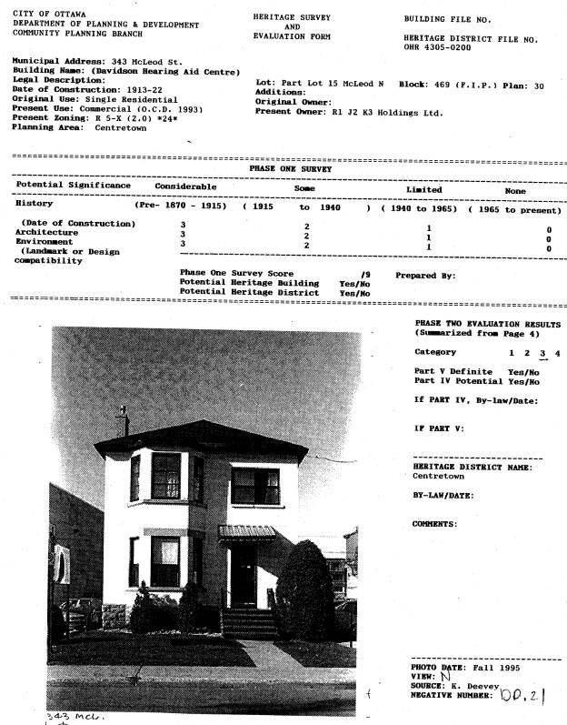
At the rear of the building, amidst a lot of parking spaces, sits 343 McLeod, a white-painted house formerly home to Davidson Hearing Centre. The heritage survey and evaluation form, created in 1996 as part of the Centretown Heritage Conservation District study, estimates the date of construction at around 1913-1922. The houses in the background will be spared its fate, but will have to contend with seven storeys of condo wall immediately adjacent.

By mid-October, the hydro connection (visible in the above photo) had been cut, but there were still blinds in the windows, which would presumably be removed before demolishing the house. The Central is, after all, destined for LEED certification.

The house was one of the first things to go, in late November.

In this shot (actually a night shot taken with long exposure), you can see that 343 McLeod was in fact a red-brick house, like so much of Centretown.

At the front of the building, a large green banner had been added to advertise the condos, and was starting to fall apart when they removed the awning (for safe keeping during construction) in November 2009.

Scaffolding was installed on the façade (the entirety of which can be captured in one frame with my new camera), and this scaffolding was covered with green mesh to minimize dust and debris falling to the ground. A couple of the workers poked their heads out to have a look.

The scaffolding is for the protection of the façade. As approved in September, the façade will be integrated into the new building, but first it will be disassembled brick-by-brick to the roofline, then the rest of it will be secured against a metal frame. The frame and façade will be moved aside, and the new foundation will be built. The façade will be replaced, and the top bit rebuilt brick-by-brick. This engineer's report (PDF) explains the process, the different options, and also shows some close-up images of the architectural details.

Moving along to the 1967 addition, demolition of it began in mid-November, with careful debricking of the rear wall, as mentioned at the time in the Bucket Feet post.

Shortly thereafter, the machines started munching away at it:

On the inside, even an institutional building is generic enough to be familiar. It's always jarring for the insides to be visible from the outside, exposed for all to see like a cut-away diagram.

Here's the de-bricked rear wall of the annex, with the window cap decorations still in place. I presume they saved the bricks for re-use with the finished product. Note also the hole punched into the main building, at the far right of this shot.

In the foreground is one of the window caps laying on the ground. Like the awning, it too was made of wood, and faced with plaster.

The implements of demolition, foreground and background.

A couple more days and a few more rooms chewed away. The surprise is starting to reveal. Do you see it?

Here it is, a remnant of a painted sign on the wall. You can also make out the shadow of the rest of it. It read "Metropolitan Tabernacle". The blog Vanished Ottawa collects photos of these old painted signs.

Surprise number two has to do with the site next door. It seems that the company that is building the Central has bought the site next door at Bank and McLeod (directly across from Tommy & Lefebvre), including the medical building. More condos are apparently on their way.

Councillor Holmes has organized a public information meeting on this new develompent on Tuesday, December 8th, 2009 at 5:30 pm at Centretown United Church (Bank & Argyle, basement), and the developer will be on hand to present plans and concept drawings.

According to Councillor Holmes' release, a mixed-use project with retail at grade and residential units above is being proposed. Not unlike the Central condominiums, whose ground-floor retail will apparently consist of yet another Shoppers Drug Mart.